
FLAGSTAFF, Ariz. — Editor's Note: The video above is from an earlier broadcast.
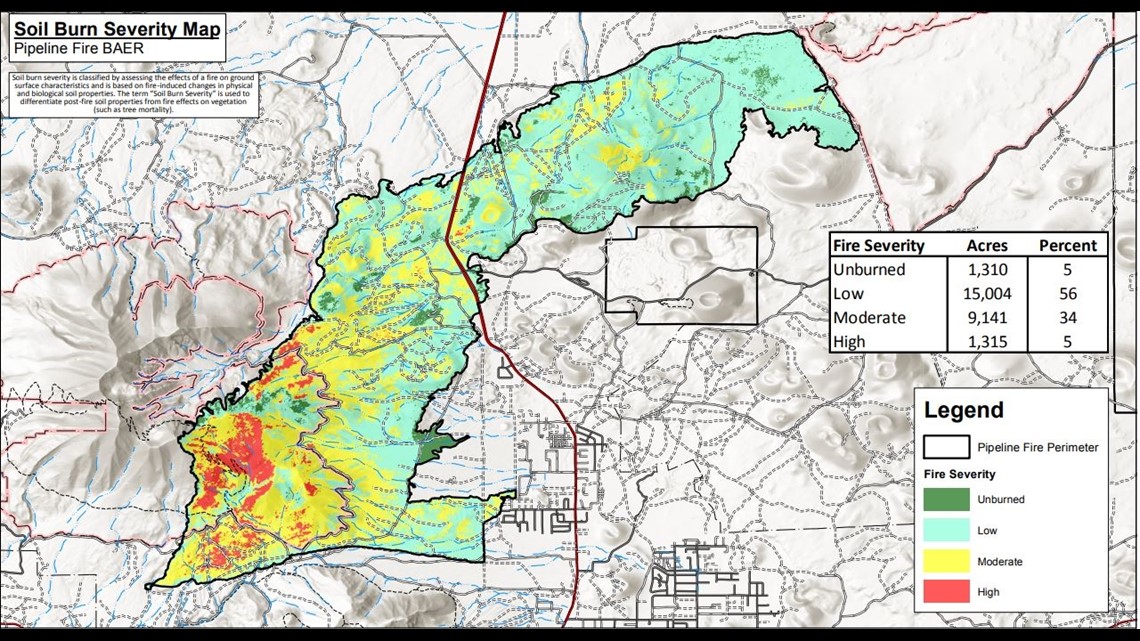
Forest Service Burned Area Emergency Response specialists have produced a soil burn severity map that identifies which areas affected by the Pipeline Fire have a higher likelihood of future erosion or flooding problems.
The BAER specialists recently finished their field data evaluation to produce the map, which outlines unburned, low, moderate, and high soil burn severity categories.
The BAER team evaluating the Pipeline Fire found that approximately 1,310 acres (1%) of the fire is unburned, approximately 15,004 acres (56%) have low soil burn severity, approximately 9,141 acres (34%) sustained a moderate SBS, and approximately 1,315 acres (5%) were identified as having high SBS.
The SBS map outcome estimates the effects of fire on soils rather than vegetation, and describes how fire affects the soil's surface and below ground.
Estimates of vegetation mortality would be one of the effects of a fire on vegetation, however, these estimates are not always correlated with the intensity of soil burn severity.
Moderate to high soil burn severity can change or damage physical, chemical, and biological soil properties. When soil properties are disrupted and altered, it results in increased runoff, erosion, and poor soil productivity.

The changes that are made to soil properties determine the degree of soil burn severity.
Water repellency generally occurs naturally in soil, but it changes as a result of fire. This is a common post-fire effect. Fire can change the strength or thickness of water repellent layers in the soil. This affects post-water runoff and can extend the time it takes for a burned area to recover.
The SBS map was created using remote sensing imagery.
The BAER team will use the SBS map as a tool to estimate post-fire erosion, sediment deliveries, stream flows and debris flow.
The Pipeline Fire soil burn severity map can be viewed here: Pipeline Fire BAER Information - InciWeb the Incident Information System (nwcg.gov)
For all of the most up to date reports about the Pipeline Fire, find them here: Pipeline Fire updates: Wildfire scorches thousands of acres | 12news.com
>> Download the 12 News app for the latest local breaking news straight to your phone.
Up to Speed
Catch up on the latest news and stories on our 12 News YouTube playlist here.