
ARIZONA, USA — Editor's note: The video above is from a newscast on June 29.
Monsoon season 2021 has officially started in Arizona!
Weather hazards could include lightning, strong outflow winds, dust storms and heavy rainfall, all of which could lead to flash flooding. Wildfire scars would be the most vulnerable during flash flooding.
12 News will provide updates on the weather here.
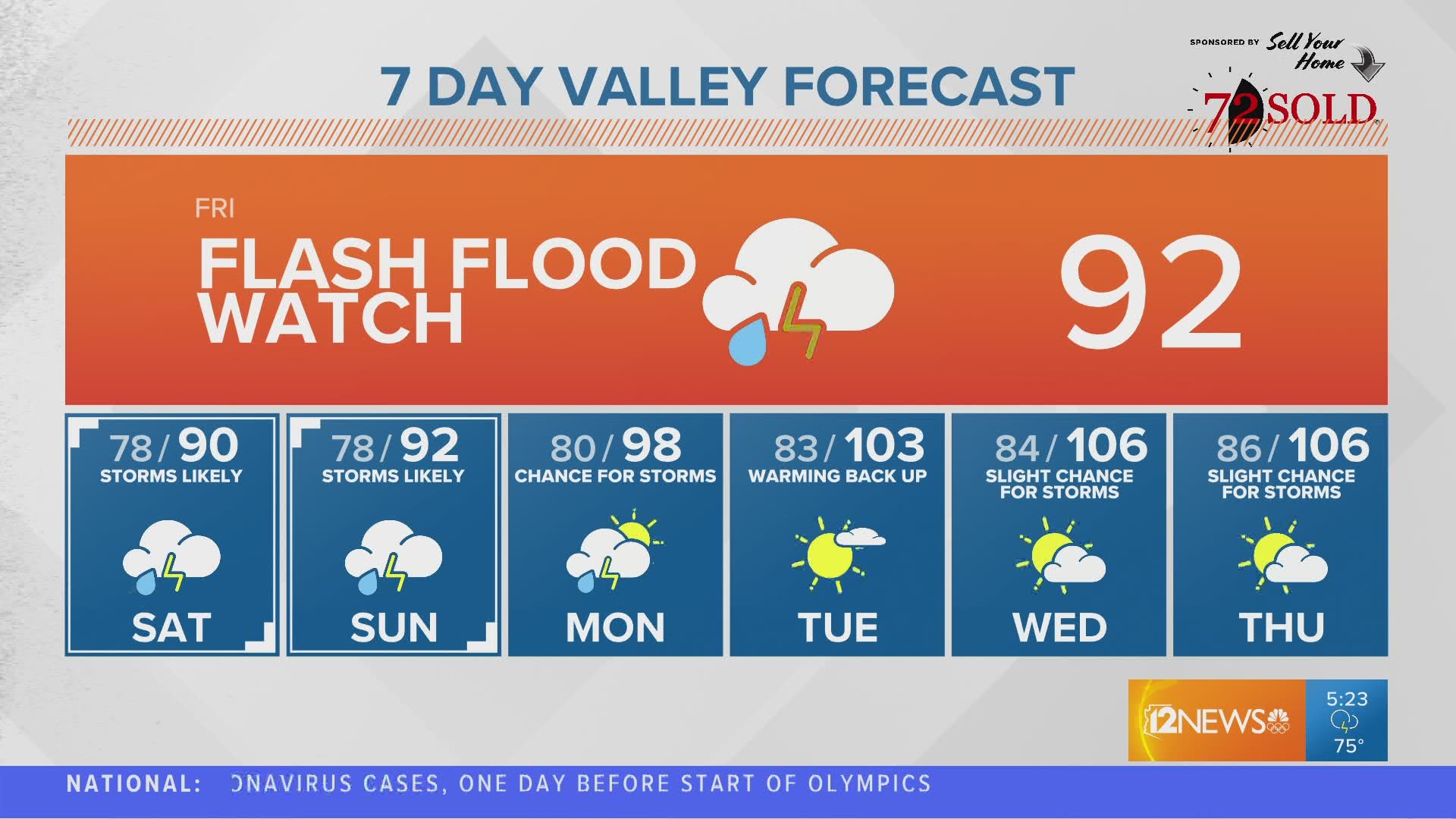
Friday, July 23
5:35 p.m.
Storms caused significant flooding across Valley roads, but the weather kept Phoenix 23 degrees cooler than the normal high in late July.
The high for Friday was just 83 degrees.
4:49 p.m.
2:00 p.m.
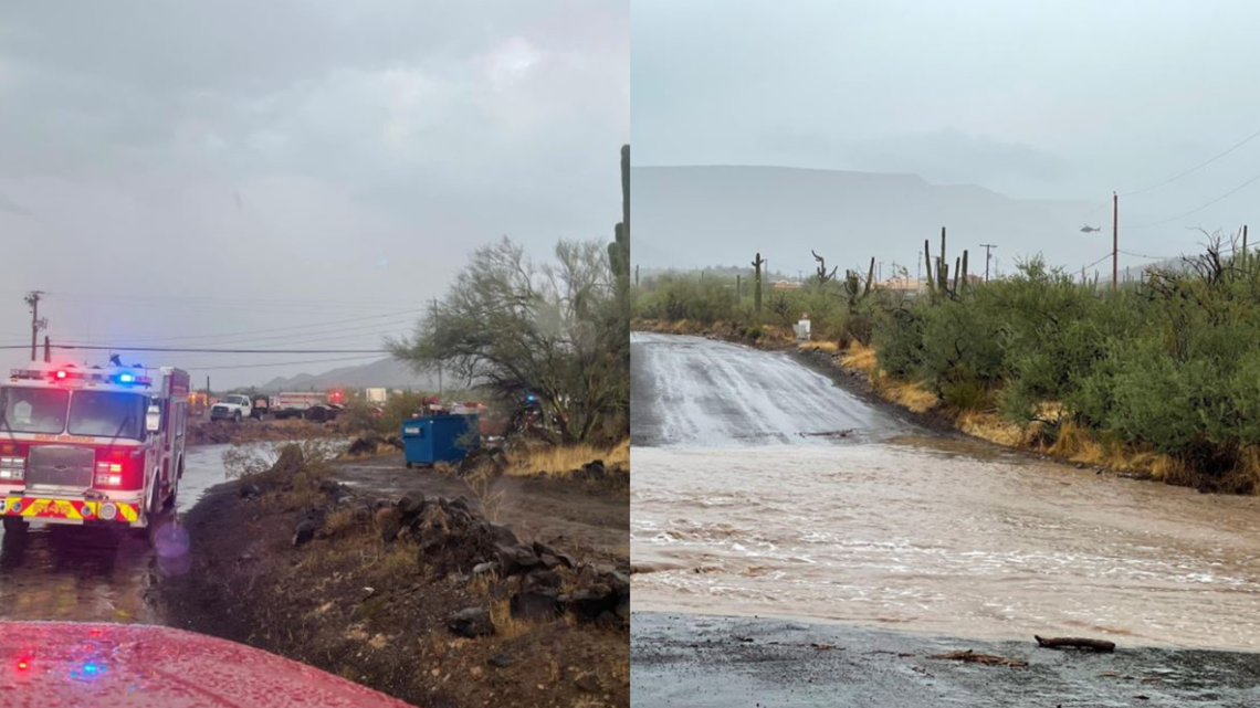
Crews were called to a water rescue near Central and Fig Springs roads in New River.
People were reportedly trapped inside of a mobile home that had water coming in the windows and the trailer was possibly going to flip over.
Two people had to be airlifted from the trailer by the Maricopa County Sheriff's Office. They were not hurt.

12:30 p.m.
RECORD BROKEN! Phoenix broke the daily rainfall record for July 23 and the rain is still falling. The previous record was 0.41'' in 2002.
11:50 a.m.
Pima County officials announced temporary closures of several trailheads and recreation areas in the Santa Catalina Mountains and numerous sections of the Chuck Huckelberry Loop due to flooding.
The closed trailheads include Finger Rock Trail, Pima Canyon Trail, Ventana Canyon Trail, Pontatoc Canyon Trail, and Bear Canyon Trail.
The U.S. Forest Service – Coronado National Forest closed a number of recreation areas in the Coronado National Forest because of flash flooding. Hikers are advised to hold off on any unnecessary activities and avoid washes, ravines, and other areas that may flood.
The closures will remain in place until further notice.
10:30 a.m.
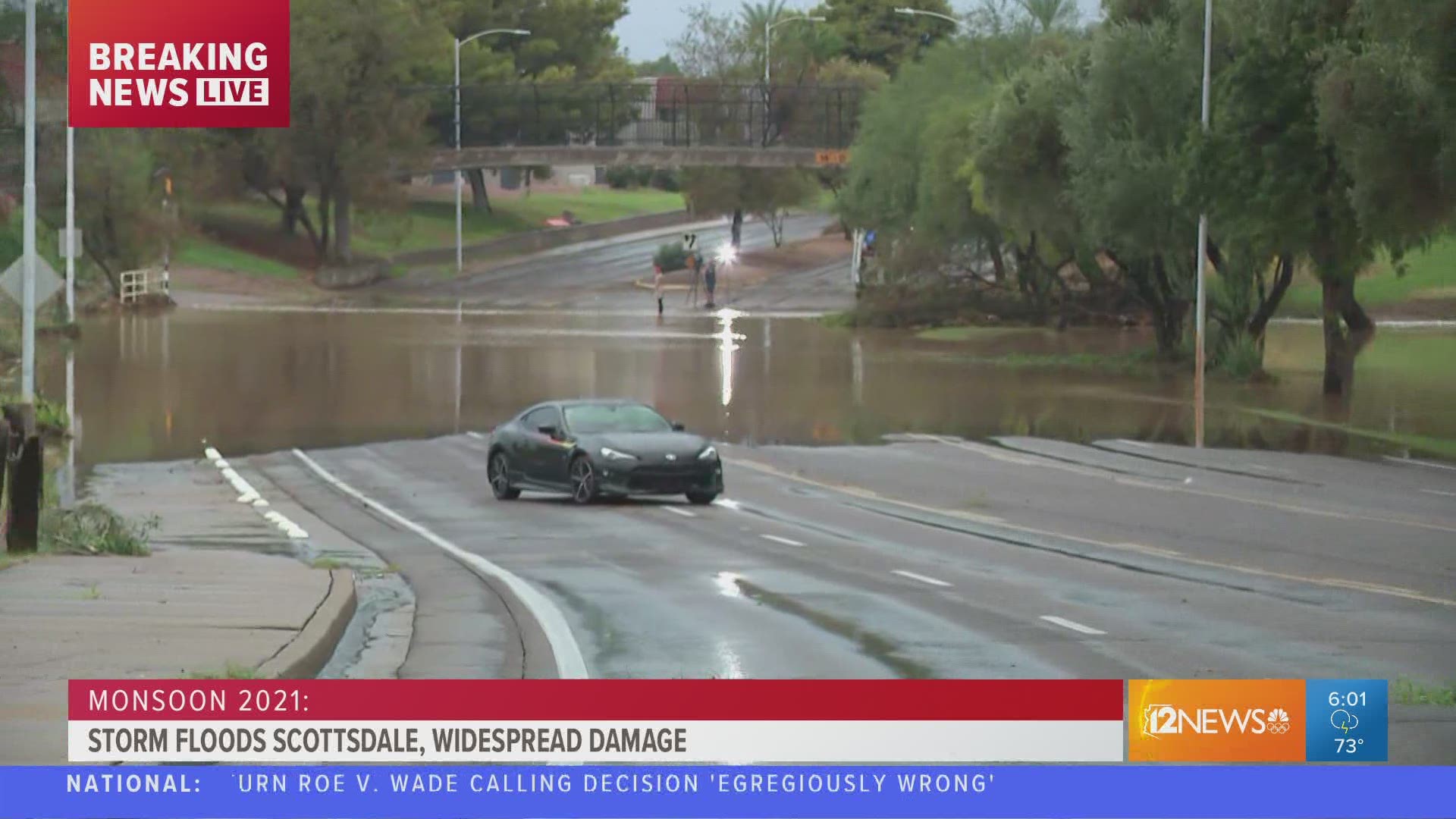
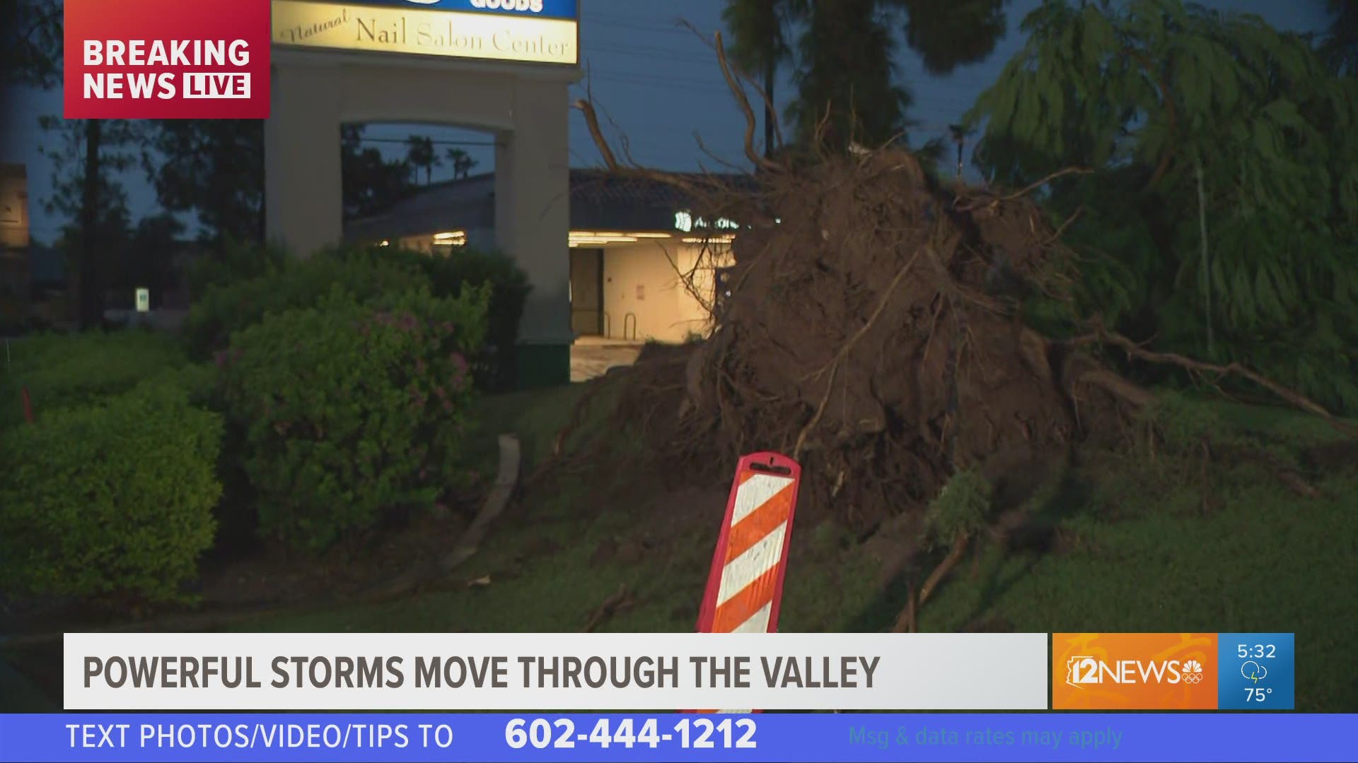
The City of Scottsdale closed a number of roads and facilities due to flooding and downed trees from rainfall moving through the area.
Crews are working to restore power, clean up debris and ensure safety across the city in the wake of last night’s storm.
Power outages were reported Friday morning in Old Town and South Scottsdale, which are slowly being restored.
Road closures
Closures include roads and low-lying areas crossing the Indian Bend Wash, a seven-mile flood control greenbelt that runs through the heart of Scottsdale. Drivers should obey traffic signs and should not cross running water or flooded areas. Current closures and other flood-prone streets include:
- Osborn Road
- Murray Lane at 77th Street
- Medlock Drive at Hayden Road
- Starlight Way at Hayden
- Jackrabbit Road at Hayden
- Pecos Lane at Hayden
- Safeway Plaza entrance, at Hayden, north of Chaparral Road
- Chaparral Park Off-Leash Area
- Chaparral Road Underpass
- Camelback Park Multiuse Path
- Horizon Park Dog Retention Area
- Eldorado Park
- Roosevelt from Miller to Hayden roads
- 87th Street, south of Thomas Road
- 84th Place, north of Roosevelt Street
- Granite Reef Road, south of Roosevelt
- Gail Road at 83rd Place
- Scottsdale Road, north of Loop 101 Freeway
- Pima Road, north of Pinnacle Peak Road
McCormick-Stillman Railroad Park and city dog parks are closed
The railroad park is closed due to downed trees. This closure will last through the weekend.
10:30 a.m.
Road closures are in place in Navajo County after flooding happened overnight. The areas affected include White Mountain Lakes, Linden, Lakeside and Heber.
Road closures include Silver Creek Drive between Daggs Street and Summer Place and Silver Creek Boulevard at Silver Creek.
A flooded road warning is on Bourdon Ranch Road near Hatchery. It is passable but drivers need to go slow.
10:10 a.m.
The National Weather Service has issued a flood warning for Scottsdale until 3:45 p.m. Friday afternoon.
"Flooding is ongoing or expected to begin shortly in the warned area," NWS said in a post on its website. "Between 0.5 and 1 inch of rain has fallen."
The service said trying to cross low water should be avoided and additional rises in washes are expected due to ongoing rainfall.
10:00 a.m.
The I-17 underpass at Greenway looks to be close to being reopened after crews drained the water from the area.
9:30 a.m.
Due to flooding from the rain 7th Avenue northbound and southbound lanes between Greenway Parkway and Coral Gables Drive are closed. Officials recommend drivers avoid flooded areas and not try to drive on flooded roads.
8:00 a.m.
The Arizona Department of Transportation said a semi-truck was crashed in the left lane on I-10 westbound to I-17 northbound at the split.
12 News Viewer Denise Toscano took a photo of the truck as she was riding in a car under the overpass.

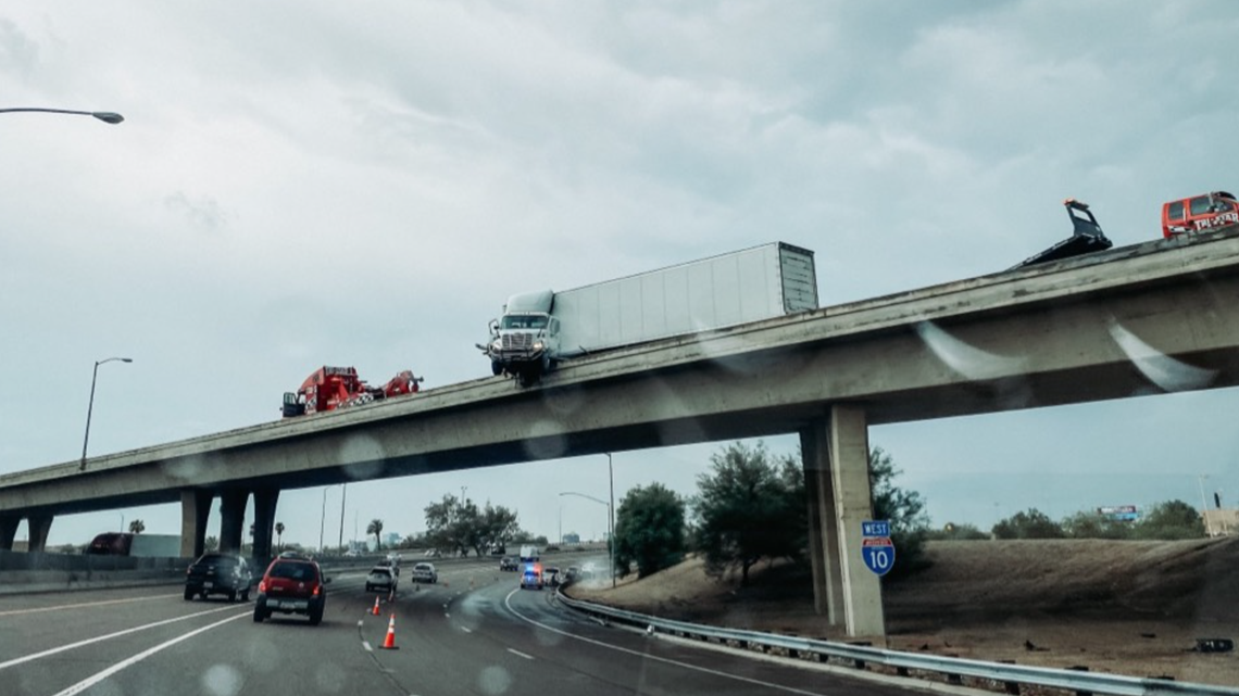
The National Weather Service at Phoenix also advised drivers to be careful on the roadways as storms continue to push through towards the Valley.
Another viewer named Amy sent in a video of sideways rain in northwest Tempe. She said her power had been out since 9:30 p.m.
Viewer David Paul sent a video of a lightning light show from Thursday night.
Thursday, July 22
10:00 p.m.
There are 8,283 APS customers and 13,001 SRP customers throughout the Valley without power due to tonight's storms.
9:45 p.m.
A flash flood warning is in place for Mesa, Chandler and Gilbert until 1:45 p.m.
8:55 p.m.
A flash flood warning has been issued for Phoenix, Scottsdale and Paradise Valley until 1 a.m.
8:27 p.m.
A severe thunderstorm warning has been put in place for Maricopa County until 8:45 p.m.
9:00 a.m.
Storms are set to hit Arizona late Thursday afternoon or early evening and could turn severe with damaging winds expected to hit up to 60 mph.
A flash flood watch is in effect for a majority of Arizona from Thursday afternoon through Saturday night. Other storm hazards will include lightning, damaging winds, dust storm and hail.
Some areas in the Valley are expected to reach multiple inches in several spots.

The National Weather Service is sharing updates on the storm forecasts as well.
FORECAST: Flash flood watch activated
Wednesday, July 21
10:26 p.m.
A severe thunderstorm warning has been issued for Phoenix, Scottsdale and Paradise Valley until 11:00 p.m.
4:40 p.m.
A significant weather warning has been extended for Maricopa County. Residents should look out for high winds and hail.
We will continue to track the incoming storms and share all the latest information on our website, mobile app, streaming services and 12 News broadcasts.
Arizona Weather
Arizona has seen its fair share of severe weather. Here is a compilation of videos from various storms across the Grand Canyon state on our 12 News YouTube playlist.